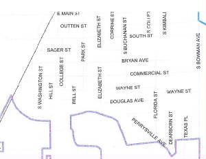
Main Street: 200 - 435
North side of street to Lauhoff
South side of street to College
Van Buren: N&W tracks to Lauhoff
South St.: Unit to 399
Sager: 100 to 399
400
to 600 blocks - south side only to Elizabeth
Bryan Ave.: Unit to 599
Commercial St.: Unit to 599
Wayne St.: 400 block
Douglas Ave.: 400 block
Beason St.: All
McDonald St: All
Lauhoff St.: west side only
S. Jackson: All
S. Washington: All
Hill St.: All
College St.: Unit - All
100 block - west side only
200-499 - All
Bell St.: All
Park St.: 200-499: All
Elizabeth St.: 200 - 499 - west side only